5K Run
Measured 2 November 2019 by Don Hughes
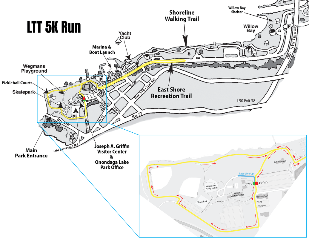
COURSE DIRECTIONS
From Start, head along edge of parking lot at Salt Museum, bear right onto S. Willow St. Pass first entrance to parking lot, turn right onto Joe Griffin Drive along end of parking area for Visitor’s Center. Pass parking lot for skate park. Turn right in the second entrance to parking lot and then immediately left onto unnamed park roadway which leads to another parking area adjacent to ball-field. At end of this parking lot turn right, passing through an open gate onto Shoreline Walking Trail, which is a paved path along the Onondaga Lake shoreline. Follow this path to junction where it merges with the East Shore Recreation Trail (ESRT) directly behind Salt Museum. Continue to follow the ESRT as it curves north. Turn left to continue on ESRT (about 20-ft wide now). Continue on ESRT, turnaround at the location designated on the map (there will be signs on the course). Retrace steps to Junction, and bear left to stay on ESRT. Finish at finish line by passing through open gate separating the trail from the parking lot. Avoid the bollards!
From Start, head along edge of parking lot at Salt Museum, bear right onto S. Willow St. Pass first entrance to parking lot, turn right onto Joe Griffin Drive along end of parking area for Visitor’s Center. Pass parking lot for skate park. Turn right in the second entrance to parking lot and then immediately left onto unnamed park roadway which leads to another parking area adjacent to ball-field. At end of this parking lot turn right, passing through an open gate onto Shoreline Walking Trail, which is a paved path along the Onondaga Lake shoreline. Follow this path to junction where it merges with the East Shore Recreation Trail (ESRT) directly behind Salt Museum. Continue to follow the ESRT as it curves north. Turn left to continue on ESRT (about 20-ft wide now). Continue on ESRT, turnaround at the location designated on the map (there will be signs on the course). Retrace steps to Junction, and bear left to stay on ESRT. Finish at finish line by passing through open gate separating the trail from the parking lot. Avoid the bollards!
5-mile Run
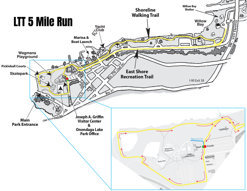
COURSE DIRECTIONS
From Start, head along edge of parking lot at Salt Museum, bear right onto S. Willow St. Pass first entrance to parking lot, turn right onto Joe Griffin Drive along end of parking area for Visitor’s Center. Pass parking lot for skate park. Turn right in the second entrance to parking lot and then immediately left onto unnamed park roadway which leads to another parking area adjacent to ball-field. At end of this parking lot turn right, passing through an open gate onto Shoreline Walking Trail, which is a paved path along the Onondaga Lake shoreline. Follow this path to junction where it merges with the East Shore Recreation Trail (ESRT) directly behind Salt Museum. Continue to follow the ESRT as it curves north. Turn left to continue on ESRT (about 20-ft wide now). Continue on ESRT, turnaround at the location designated on the map (there will be signs on the course). Continue back on ESRT then follow signs to bear right onto the Shoreline Walking Trail, stay on the Shoreline Walking Trail until your reach the Junction. Once you reach the Junction, bear left to stay on ESRT. Finish at finish line by passing through open gate separating the trail from the parking lot. Avoid the bollards!
From Start, head along edge of parking lot at Salt Museum, bear right onto S. Willow St. Pass first entrance to parking lot, turn right onto Joe Griffin Drive along end of parking area for Visitor’s Center. Pass parking lot for skate park. Turn right in the second entrance to parking lot and then immediately left onto unnamed park roadway which leads to another parking area adjacent to ball-field. At end of this parking lot turn right, passing through an open gate onto Shoreline Walking Trail, which is a paved path along the Onondaga Lake shoreline. Follow this path to junction where it merges with the East Shore Recreation Trail (ESRT) directly behind Salt Museum. Continue to follow the ESRT as it curves north. Turn left to continue on ESRT (about 20-ft wide now). Continue on ESRT, turnaround at the location designated on the map (there will be signs on the course). Continue back on ESRT then follow signs to bear right onto the Shoreline Walking Trail, stay on the Shoreline Walking Trail until your reach the Junction. Once you reach the Junction, bear left to stay on ESRT. Finish at finish line by passing through open gate separating the trail from the parking lot. Avoid the bollards!
Kid's "Fast Feet" Run
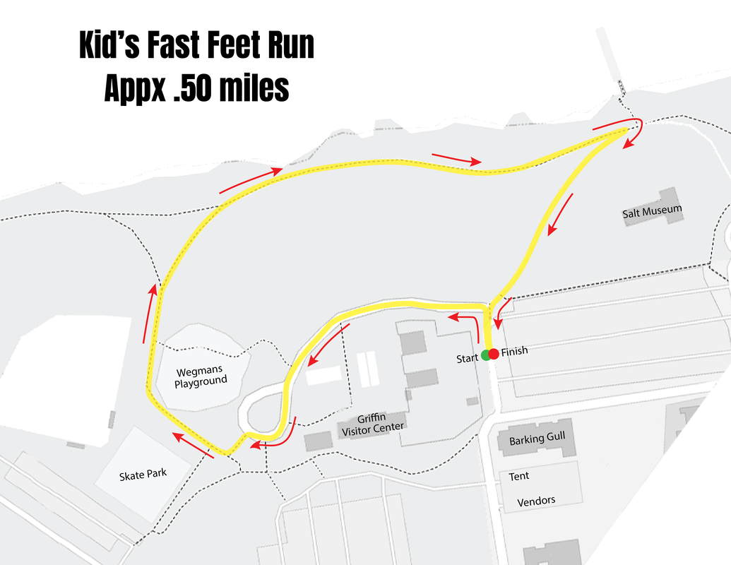
COURSE DIRECTIONS
From Start, head left behind the Griffin Visitor Center towards the Wegmans Playground. Approaching the round-about, stay left and exit the round-about at the opposite end. Turn right on path that leads you around the Wegmans Playground. Continue to bear right at the split as you enter on the Shoreline Walking Trail along the lake. Continue on the Shoreline Walking Trail until you come to the Junction, then make a right hairpin turn at the Junction back onto ESRT. Finish at finish line by passing through open gate separating the trail from the parking lot. Avoid the bollards!
From Start, head left behind the Griffin Visitor Center towards the Wegmans Playground. Approaching the round-about, stay left and exit the round-about at the opposite end. Turn right on path that leads you around the Wegmans Playground. Continue to bear right at the split as you enter on the Shoreline Walking Trail along the lake. Continue on the Shoreline Walking Trail until you come to the Junction, then make a right hairpin turn at the Junction back onto ESRT. Finish at finish line by passing through open gate separating the trail from the parking lot. Avoid the bollards!
Dog Walk
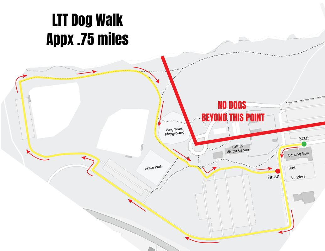
COURSE DIRECTIONS
Dog walkers will line up along Lake Drive on the side of the Barking Gull. From Start, walkers will turn left onto S. Willow Street and continue until turning right onto Joe Griffin Drive at the end of the large parking lot. Continue on Joe Griffin Drive until you reach the small parking lot in front of the Skate Park, turn right in the second entrance of the small parking lot then immediately turn left onto the unnamed road. This road will lead you to another parking lot next to the ball fields. At end of this parking lot turn right, passing through an open gate onto Shoreline Walking Trail, which is a paved path along the Onondaga Lake shoreline. Bear right at the split, coming along the right side of the Wegmans Playground. After you pass the playground, continue straight through the bollards as you turn left at the edge of the parking lot at the Griffin Visitor Center. Finish at the edge of the parking lot as it opens on S. Willow Street.
*Dogs are NOT allowed on the running courses.